Here are some helpful tools to help you research development and land use changes in Albany Pine Bush.
Properties on the Planning Board Agendas
See our Planning Board Agenda Tracker.
Search a Property
You can search a property here, however it must be in a very specific format to match the tax record, like this describing the property: 20 New Karner Rd, Town of Guilderland. If you don’t have that level of detail or nothing is returned, you should use the Google Spreadsheet below, search for the property and then click on the link in the spreadsheet.
Alternatively, you can search by Tax Map ID, such as 41.00-2-63. This is a best way to search if you know the Tax ID number to avoid pulling the wrong record.
If you know the coordinates of the parcel you are interested in you can search by those too.
The Preserve Today
Albany Pine Bush Preserve and Study Area:
https://savethepinebush.org/leaflet/spbmap.php
- Green areas have been preserved, yellow areas are conservation easements.
- Blue border represents area under study by Albany Pine Bush Commission for potential preservation and management as Pine Bush, area defined by Article 46 of Environmental Conservation Law
Proposed Developments we are tracking:
https://savethepinebush.org/leaflet/proposed.htm
The Preserve Tomorrow
Albany Pine Bush Commission Vision Plan, by commission preservation recommendation:
https://savethepinebush.org/leaflet/spbmap.php
- Albany Pine Bush Preserve (Green), Conservation Easements (Yellow), Areas Recommend for Full Protection by APBC (Red), Areas Recommend for Partial Protection by APBC (Orange), Areas Recommend as Open Space (Blue)
Historic Topographic Maps
Compare 1893, 1927/30, 1953/54/55, 1980, 1995, 2020 Topographic Maps:
https://savethepinebush.org/leaflet/apbtopo.htm
- This shows the USGS Topographic Maps for the Albany Pine Bush Study Area, showing development over the years.
- Areas shown in green are current preserve, while yellow areas are conservation easements.
Current Property Property Ownership
Save the Pine Bush put together a spreadsheet that brings together the following data for each property in the Albany Pine Bush study area:
- Links to Save the Pine Bush Tax Mapper, Google Maps, Albany County Tax Maps (PDF)
- 2021 Albany County Tax Rolls (base data)
- 2020 NYS Office of Real Property Services Tax Rolls (* some records do not match county tax rolls as maps have changed slightly)
- 2017 Albany Pine Bush Commission Vision Plan (* joined in GIS software, may occasionally match bordering properties due to mapping inaccuracies)
This data can help volunteers spot proposed developments in Albany Pine Bush, including in areas that the Albany Pine Bush Commission recommends for full protection. This document is fully searchable and can be filtered in Excel. It contains over 9,300 property tax records and 117 columns, so it’s recommended you either use Microsoft Excel 2010+ or the free LibreOffice 7.2+ that can support opening large files. To filter the document, you may need to take the file out of protected mode.
Google Spreadsheet: https://docs.google.com/spreadsheets/d/1p42SvyRXXuAda9DwZOdLMeu_RZOP65AEYyuekWq38IY/edit#gid=438396657
Microsoft Excel Spreadsheet: https://savethepinebush.org/Albany Pine Bush Parcels.xlsx
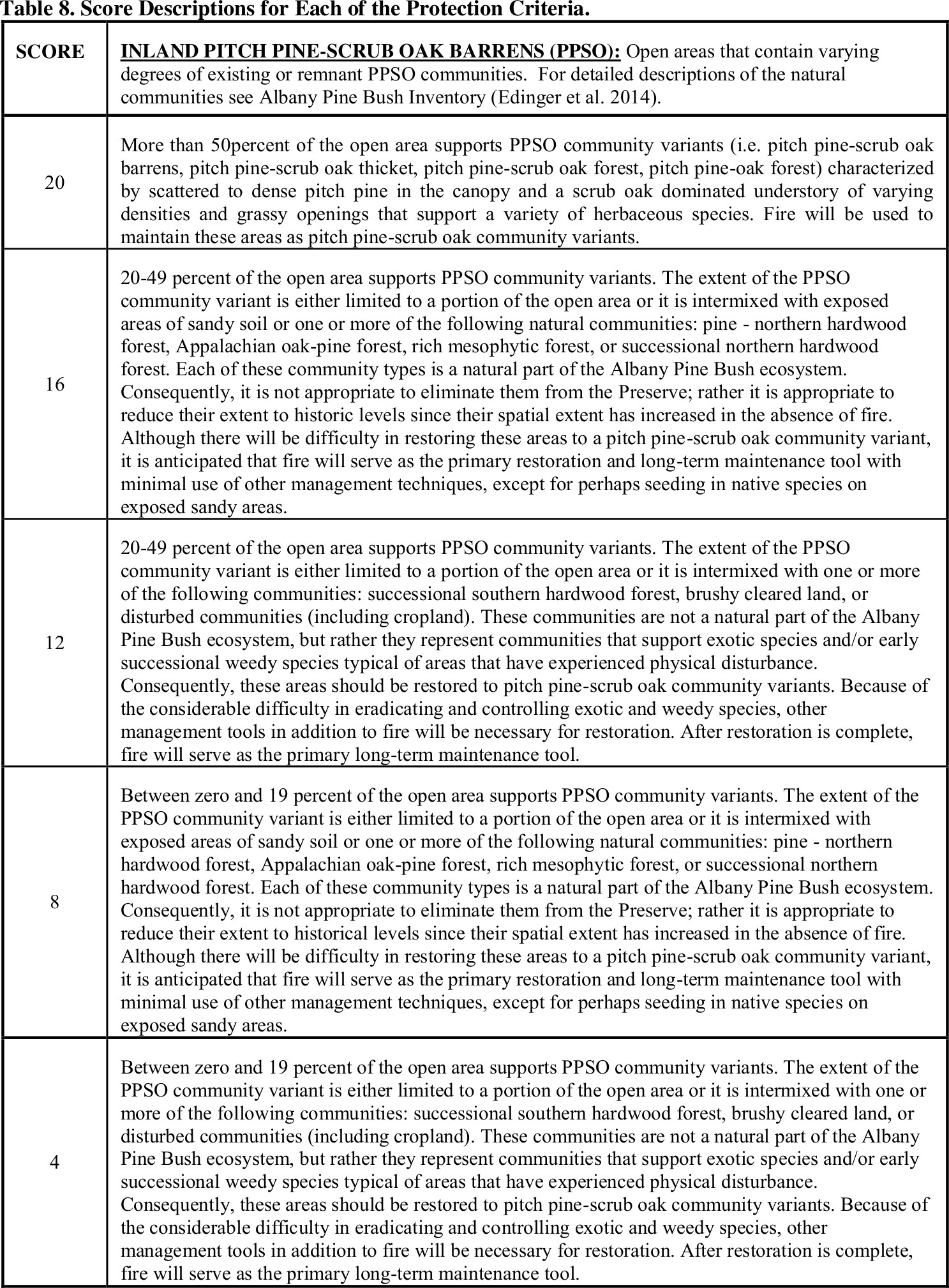
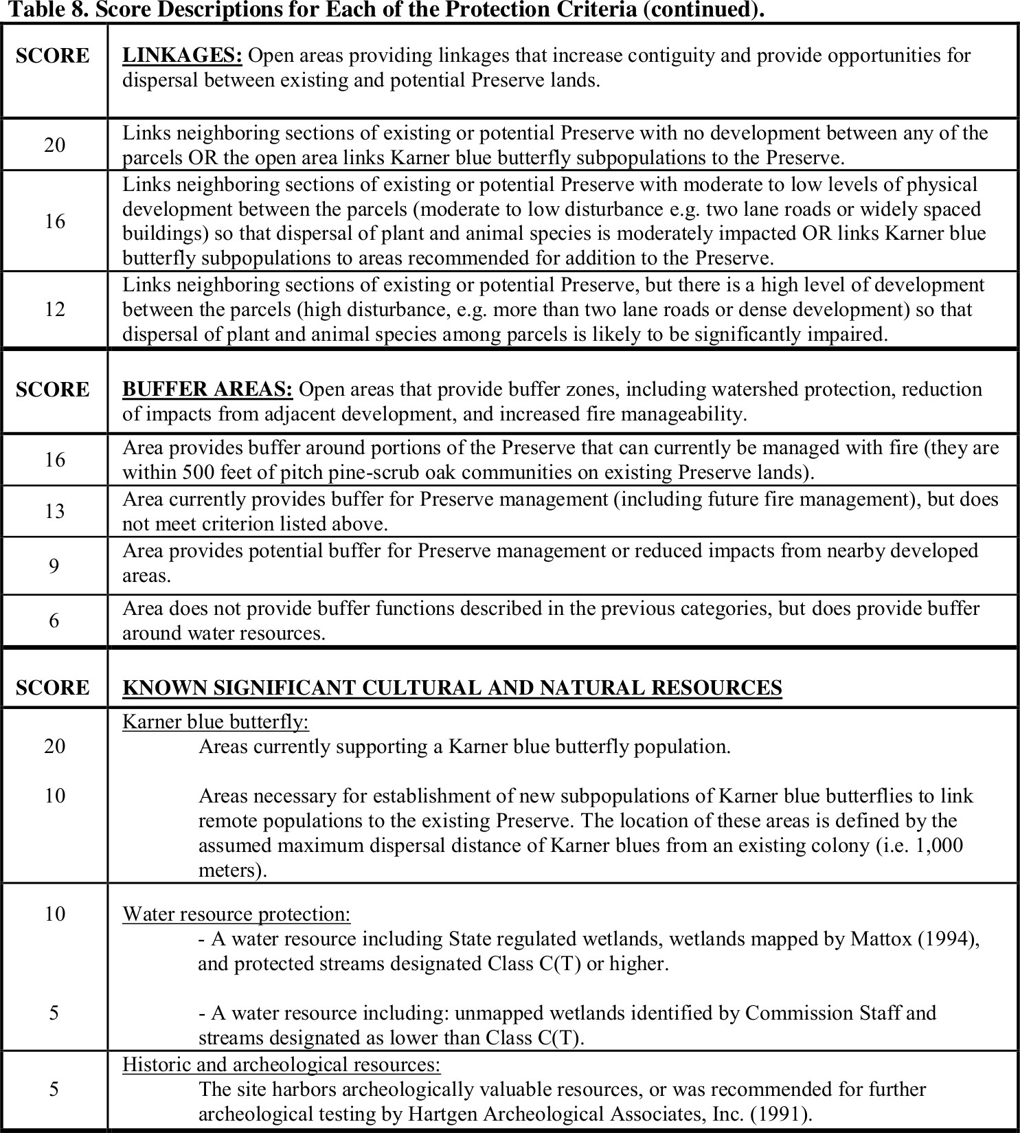
Explanation of the Commissions Pine Bush Scoring System (shown on Columns CO-DK in the above spreadsheet)
From page 52 of the Albany Pine Bush Preserve Commission 2017 Management Plan Update:
Consistent with the approach used in previous plans, the value assigned to each criterion was based on the area’s contribution to the viability of the Preserve. Those that contribute more received a higher possible maximum score (e.g. 20). Conversely, those that are less critical to the viability of the Preserve (but still important Pine Bush resources) received a lower possible maximum score. By assigning an area scores for each of the criteria and summing their values, the total scores provided the basis for determining protection recommendations. The scores and scoring criteria are outlined in Table 9 and are consistent with previous Management Plans.
The range of scores possible for each criterion reflects its relative importance within the ranking system. Pitch pine-scrub oak barrens, linkages, and Karner blues were ranked highest (i.e. maximum score of 20) on the basis of rarity and importance. Although buffer areas are very important to maintaining the integrity of the Preserve, they are somewhat less critical to Preserve viability than linkages, pitch pine-scrub oak barrens, and the presence of Karner blues. Buffers are most important where they facilitate fire management. For this reason, areas within 500 feet of Preserve lands that can currently be managed with fire received a high score of 16. Without such buffers, Commission experience has been that habitat restoration and management with fire is extremely difficult.
Google Spreadsheet (see 2017 Vision Plan APBC tab): https://docs.google.com/spreadsheets/d/1p42SvyRXXuAda9DwZOdLMeu_RZOP65AEYyuekWq38IY/edit#gid=438396657
Microsoft Excel Spreadsheet (see 2017 Vision Plan APBC tab): https://savethepinebush.org/Albany Pine Bush Parcels.xlsx
| Area Location | Area Number | PPSO 4-20 | Link | Karner Blue | Buffer | Water Resources | Hist. Arch. | Total Score | Acres | Preserve Goal | Municipality |
| 17 Vision TRACT LOCA | 17 Vision TRACT NO | 17 Vision PP SO | 17 Vision LINK | 17 Vision KARNER BLU | 17 Vision BUFFER | 17 Vision WETLANDS | 17 Vision HIS ARCH | 17 Vision TOTAL SCOR | 17 Vision ACRES | 17 Vision P GOAL | |
| CT | CU | CV | CW | CX | CY | CZ | DA | DB | DC | DE | |
| NIMO Prow (West) | 21a | 20 | 16 | 20 | 20 | 10 | 0 | 86 | 11.71 | Open Space | Colonie |
| NIMO Prow (West) | 21b | 20 | 16 | 20 | 20 | 10 | 0 | 86 | 15.31 | Open Space | Guilderland |
| NiMo Prow | 21d | 20 | 16 | 20 | 10 | 10 | 0 | 86 | 32.66 | Open Space | Colonie |
| N Pine Lane | 29b | 20 | 20 | 16 | 20 | 5 | 5 | 86 | 22.83 | Open Space | Albany |
| N Pine Lane | 29c | 8 | 20 | 16 | 20 | 10 | 5 | 79 | 1.15 | Full Protection | Albany |
| Apollo Drive | 74 | 20 | 20 | 16 | 20 | 0 | 0 | 76 | 1.38 | Full Protection | Colonie |
| Pine Lane South | 84 | 20 | 20 | 16 | 20 | 0 | 0 | 76 | 1.46 | Full Protection | Albany |
| Rifle Range Rd Terminus | 51a | 20 | 20 | 16 | 0 | 10 | 5 | 71 | 43.02 | Open Space | Colonie |
| SW Morris Rd/Kings Rd | 53 | 4 | 20 | 16 | 20 | 10 | 0 | 70 | 114.35 | Full Protection | Colonie |
| Apollo Drive North | 76 | 20 | 20 | 16 | 10 | 0 | 0 | 66 | 0.96 | Full Protection | Colonie |
| Old State Rd West (South) | 82 | 20 | 20 | 16 | 0 | 5 | 5 | 66 | 2.85 | Full Protection | Guilderland |
| Wetland S Albany St | 35a | 16 | 20 | 13 | 0 | 10 | 5 | 64 | 71.36 | Full Protection | Colonie |
| Wetland S Albany St | 35b | 16 | 20 | 13 | 0 | 10 | 5 | 64 | 29.49 | Full Protection | Colonie |
| Wetland S Albany St | 35c | 16 | 20 | 13 | 0 | 10 | 5 | 64 | 34.62 | Full Protection | Colonie |
| Wetland S Albany St | 35d | 16 | 20 | 13 | 0 | 10 | 5 | 64 | 121.31 | Full Protection | Colonie |
| Wetland S Albany St | 35e | 16 | 20 | 13 | 0 | 10 | 5 | 64 | 30.52 | Full Protection | Colonie |
| Wetland S Albany St | 35f | 16 | 20 | 13 | 0 | 10 | 5 | 64 | 7.11 | Full Protection | Colonie |
| Wetland S Albany St | 35g | 16 | 20 | 13 | 0 | 10 | 5 | 64 | 60 | Full Protection | Colonie |
| Apollo Drive West | 75 | 12 | 20 | 16 | 10 | 0 | 5 | 63 | 4.86 | Full Protection | Colonie |
| Rifle Range Rd Terminus | 51b | 20 | 20 | 16 | 0 | 0 | 5 | 61 | 11.75 | Open Space | Colonie |
| N Prow & E Rapp Rd | 62 | 20 | 20 | 16 | 0 | 0 | 5 | 61 | 6.72 | Full Protection | Albany |
| NW Rt 155/Rt 20 | 3 | 16 | 16 | 13 | 0 | 10 | 5 | 60 | 116.32 | Full Protection | Guilderland |
| NW Morris Rd/Kings Rd south | 52c | 8 | 16 | 13 | 0 | 10 | 5 | 60 | 18.61 | Full Protection | Colonie |
| NW Morris Rd/Kings Rd south | 52d | 8 | 16 | 13 | 0 | 10 | 5 | 60 | 9.56 | Full Protection | Colonie |
| S. Frontage Rd Terminus | 78 | 4 | 20 | 16 | 20 | 0 | 0 | 60 | 6.24 | Full Protection | Albany |
| Rt 155 Corridor | 36 | 8 | 16 | 13 | 20 | 0 | 0 | 57 | 35.21 | Open Space | Albany |
| N Hungerkill/W Ravine bottom | 33b | 8 | 20 | 13 | 0 | 10 | 5 | 56 | 66.11 | Open Space | Guilderland |
| NW Morris Rd/Kings Rd | 52a | 8 | 20 | 13 | 0 | 10 | 5 | 56 | 120.89 | Full Protection | Colonie |
| NW Morris Rd/Kings Rd south | 52b | 8 | 20 | 13 | 0 | 10 | 5 | 56 | 81.61 | Full Protection | Colonie |
| Michael Drive North | 71a | 8 | 20 | 13 | 0 | 10 | 5 | 56 | 51.75 | Full Protection | Colonie |
| Michael Drive South | 71b | 8 | 20 | 13 | 0 | 10 | 5 | 56 | 65.46 | Full Protection | Colonie |
| Between Kings Rd & Curry Rd | 72a | 8 | 16 | 16 | 0 | 10 | 5 | 55 | 67.04 | Full Protection | Colonie |
| Between Kings Rd & Curry Rd | 72b | 12 | 20 | 16 | 20 | 10 | 5 | 55 | 86.61 | Full Protection | Colonie |
| NiMO Prow | 21c | 8 | 16 | 20 | 0 | 10 | 0 | 54 | 35.78 | Open Space | Colonie |
| Rifle Range Rd Terminus | 25 | 8 | 20 | 16 | 0 | 10 | 0 | 54 | 31.87 | Open Space | Colonie |
| N Pine Lane | 29a | 20 | 20 | 13 | 0 | 0 | 0 | 53 | 12.02 | Full Protection | Albany |
| Btween Kings/Morris/Curry | 43 | 12 | 20 | 16 | 0 | 5 | 0 | 53 | 54.66 | Full Protection | Colonie |
| Btween Conrail/Morris/Kings | 44a | 8 | 20 | 16 | 0 | 5 | 0 | 49 | 96.73 | Full Protection | Colonie |
| Between Curry Rd & I-90 | 73 | 4 | 16 | 9 | 10 | 5 | 5 | 49 | 96.44 | Full Protection | Guilderland |
| W of Rt 155 (South) | 9 | 4 | 16 | 13 | 0 | 10 | 5 | 48 | 4.02 | Full Protection | Albany |
| Between Kings and Curry Ext. | 17c | 16 | 16 | 16 | 0 | 0 | 0 | 48 | 26.76 | Full Protection | Colonie |
| Golf Course Area | 28 | 4 | 16 | 13 | 0 | 10 | 5 | 48 | 144.69 | Open Space | Guilderland |
| Cordell Rd North | 70 | 8 | 16 | 9 | 0 | 10 | 5 | 48 | 86.89 | Full Protection | Colonie |
| Dennis Terrace | 83 | 12 | 20 | 16 | 0 | 0 | 0 | 48 | 1.73 | Full Protection | Colonie |
| Kings Rd East | 86 | 12 | 20 | 16 | 0 | 0 | 0 | 48 | 1.65 | Full Protection | Colonie |
| W Rapp Rd S | 57 | 4 | 20 | 16 | 0 | 0 | 5 | 45 | 17.36 | Partial Protection | Guilderland |
| Between Curry & Thruway (West) | 55 | 4 | 16 | 9 | 0 | 10 | 5 | 44 | 149.32 | Full Protection | Guilderland |
| Btween Lydius & Thruway | 18 | 4 | 16 | 16 | 0 | 5 | 5 | 42 | 86.19 | Full Protection | Guilderland |
| Ravine Corrider/N Willow St | 46 | 0 | 16 | 9 | 0 | 10 | 5 | 40 | 64.7 | Open Space | Guilderland |
| Apollo Dr. | 87 | 8 | 16 | 16 | 0 | 0 | 0 | 40 | 1.4 | Full Protection | Colonie |
| N Watervliet/S Conrail | 27 | 0 | 16 | 13 | 0 | 10 | 0 | 39 | 24.19 | Full Protection | Colonie |
| NW Conrail/N-way | 24 | 4 | 16 | 13 | 0 | 5 | 0 | 38 | 15.86 | Open Space | Colonie |
| Btween Curry & Thruway East | 17a | 12 | 16 | 9 | 0 | 0 | 0 | 37 | 60.54 | Full Protection | Guilderland |
| Btween Curry & Thruway | 17b | 12 | 16 | 9 | 0 | 0 | 0 | 37 | 9.54 | Full Protection | Guilderland |
| NE Wash Ave Ext/Rt 155 | 42 | 16 | 12 | 9 | 0 | 0 | 0 | 37 | 7.88 | Full Protection | Albany |
| Btween Conrail/Morris/Kings | 44b | 8 | 16 | 13 | 0 | 0 | 0 | 37 | 7.63 | Full Protection | Colonie |
| Brookview Drive | 60 | 4 | 12 | 9 | 0 | 10 | 0 | 37 | 72.27 | Partial Protection | Guilderland |
| Landfill | 23 | 0 | 20 | 16 | 0 | 0 | 0 | 36 | 137.41 | Open Space | Albany |
| S Blueberry Hill | 61 | 20 | 0 | 16 | 0 | 0 | 0 | 36 | 11.28 | Full Protection | Guilderland |
| SW Rens Lake | 34 | 12 | 0 | 13 | 0 | 10 | 0 | 35 | 9.01 | Full Protection | Albany |
| Morris Street | 59 | 0 | 16 | 9 | 0 | 10 | 5 | 34 | 35.27 | Partial Protection | Colonie |
| Conrail | 22 | 0 | 20 | 13 | 0 | 0 | 0 | 33 | 116.37 | Open Space | Colonie |
| Cook Park | 38 | 4 | 0 | 13 | 0 | 10 | 5 | 32 | 41.23 | Open Space | Colonie |
| Wetland NW of City Preserve | 31 | 8 | 0 | 13 | 0 | 5 | 5 | 31 | 67.04 | Partial Protection | Colonie |
| E of Route 155 (North) | 77 | 4 | 16 | 6 | 0 | 5 | 0 | 31 | 4.77 | Full Protection | Colonie |
| SW Morris/Curry Rd | 54 | 4 | 16 | 9 | 0 | 0 | 0 | 29 | 229.98 | Full Protection | Guilderland |
| S Hungerkill/N of Rt 20 | 32 | 4 | 0 | 9 | 0 | 10 | 5 | 28 | 366.14 | Partial Protection Gui | lderland |
| NE Conrail/Northway | 30 | 16 | 0 | 0 | 0 | 10 | 0 | 26 | 22.24 | Partial Protection | Colonie |
| N Hungerkill/Town Park | 33d | 8 | 0 | 13 | 0 | 0 | 5 | 26 | 7.14 | Open Space | Guilderland |
| SW of Madison Ave Ext/Rt 155 | 45 | 4 | 16 | 0 | 0 | 0 | 5 | 25 | 0.89 | Partial Protection | Albany |
| Cemetery | 81 | 8 | 0 | 9 | 0 | 0 | 5 | 22 | 43.69 | Open Space | Guilderland |
| Old State Rd West (North) | 80 | 0 | 0 | 16 | 0 | 5 | 0 | 21 | 45.61 | Open Space | Guilderland |